The Origins of Newmarket
If you can help in this quest and have any new details to add please E-MAIL]
-
The location of the new market
-
The creation of Newmarket came about quite simply because this area
was an ideal location for the site of a new market. It does seem a bit
too obvious really, but to explain this in a bit more detail let's look
at what initially produced this 'Goldilocks' environment.
- Local archaeological investigations have found evidence for habitation
in this area going back to pre-historic times, the Iceni, through Roman occupation, then the Anglo-Saxons, and all the way through to the Medieval period, during which time the new market was created.
The major reasons for this happening is that firstly the locality was directly on the route of the Icknield Way, an ancient traveller's route across what geologists call the Cambridgeshire Chalk Plain, the East Anglian Plain or for our particular part of it, the Newmarket Chalk Heath - i.e the heathland that we know so well.
Secondly this geology meant that there were many springs and small waterways emerging from deep underground coming up through the chalk, ensuring a source of fresh water for both occupiers and travellers.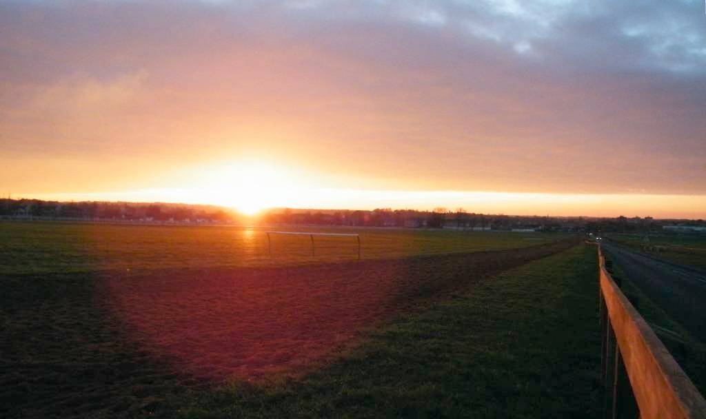
The Moulton Road Heath
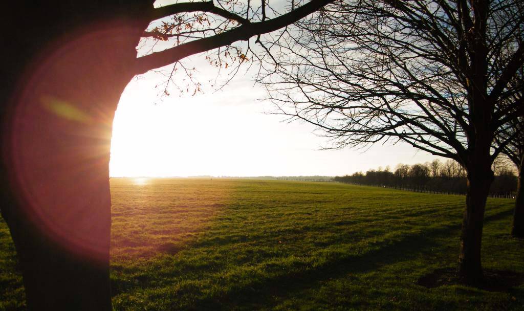
The Cambridge Road Heath
[For more details about these springs, waterways and the chalk aquifer see the page for the Watercourse.]
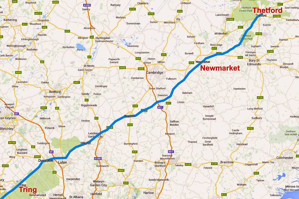
The above maps show quite clearly how the geology of this area influenced the route of the Icknield Way: as the 'Way' follows an almost straight line direct from Tring, past Dunstable, Luton, Hitchin and Royston, through Newmarket and onto Thetford, skirting closely along the north-western edge of the Chalk Plain.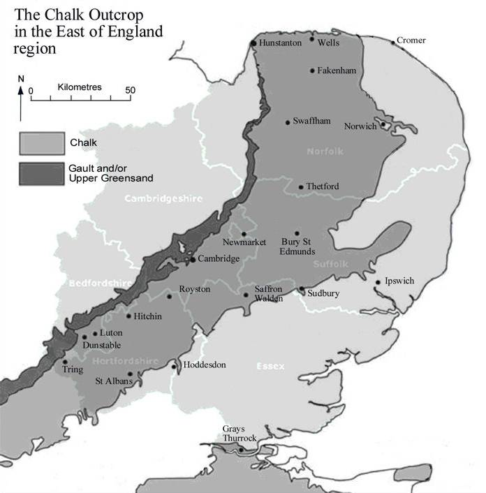
The East Anglian Plain / Cambridgeshire Chalk Plain
Map of the Icknield Way
 https://en.wikipedia.org/wiki/Icknield_Way
-
To the north-west of this, any route through was blocked by the fens, which
originally being much marshier then than they are now made for highly
problematic journeys for travellers, both physically and also from the ever-present risk of
malaria. Then to the south-east of the Icknield Way the clay-capped hills
now known as the East Anglian Heights, were at that time densely wooded, also
making travelling very difficult.
To put it quite simply it was a case of Hobson's choice for an historic traveller's route through the area. And then also to ensure that this remained the case the Bran Ditch, Brent Ditch, Fleam Dyke and most notably the Devil's Dyke earthworks were constructed [present opinion is that this was most likely to have been started during Roman times, though not by the Romans themselves], which as each of them cuts perpendicularly across the route, became both a means of defending the area from outsiders and also of managing the through traffic.
Hence because of the pinch-point at this location it's no surprise that to capitalise on this traffic eventually a market was created here to provide both a means of trade and also of sustenance for any travellers.
[The heartland of the Iceni was mostly in Norfolk, but their lands also extended into Suffolk and Cambridgeshire, where it's reputed that their capital was here at Exning. One theory has it that the Icknield Way may be named after the Iceni, but another more probable origin comes from considering an ancient version of the name, which was Ikenyld. Iken is known to have been the Briton word for 'wedge' - therefore the meaning inferred here for the Icknield Way was that it was a wedge in the land cutting across the chalk plain, running in-between the low fenlands on one side and the East Anglian Heights on the other.]
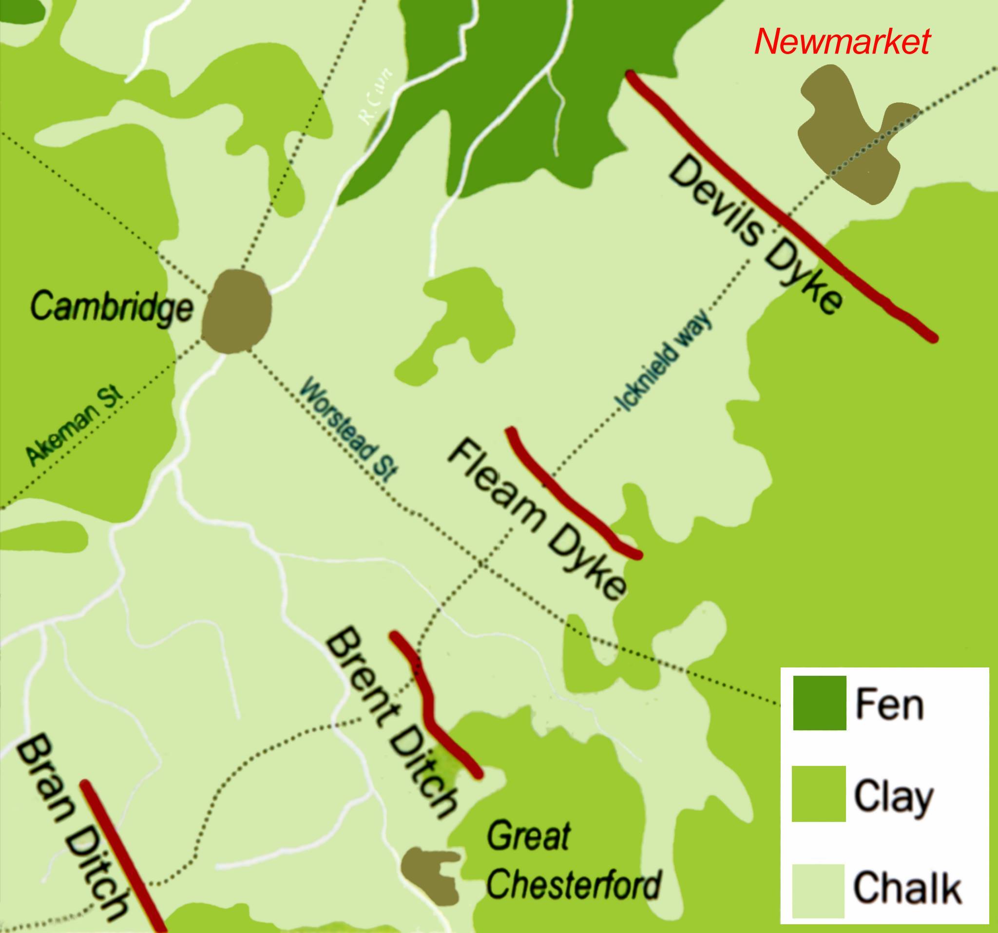
Map of the Cambridgeshire Dykes
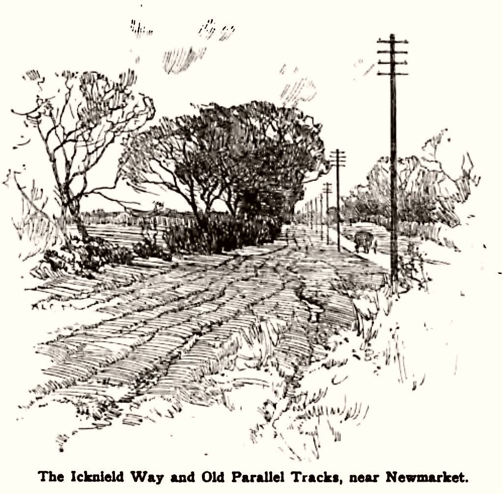
- One point of note here - the Icknield Way is shown on most maps as a single
line, just one 'road' - in reality the actual 'Way' was much less well-defined
than this, and it existed as a multitude of meandering tracks, all taking approximately the same overall route.
The line that we draw on the maps today was probably just the most well-worn of these various trackways, and hence as time progressed it became the preferred route, and eventually evolved into the modern-day roads that follow the course of the 'Way', such as the A505 and A11.
-
By 1472, as detailed by Peter May in his books about Newmarket, it had become a single road through
the town, passing in front of All Saints church and following the line of what
later became Palace Street - shown as Ikenelseway on the map below.
Many thanks to the Newmarket Local History Society for the above 1472 map as produced by the Reverend Peter May. Copies of his book 'Newmarket Mediaeval & Tudor' can be purchased in bookshops and online.]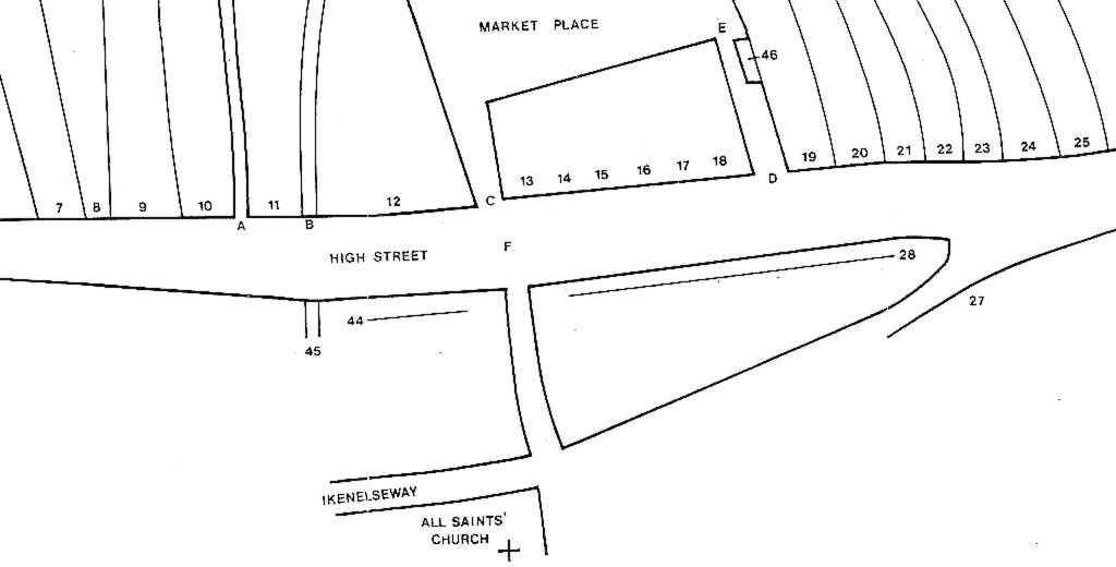
Newmarket Map 1472
-
Starting in 1200
-
One aspect that must be understood when investigating the
origination of the town is that initially the
present location of Newmarket was in the manor of Exning (known
variously in Medieval times as Esselinge, Exnyng, Exynngge, Exninge, Exening, Exelinges, Yxninge,
Yxnyng, Ixenyng, Ixinge, Ixlinges, Ixning, Ixninge, Ixninges, Ixnigham, Ixnyng, Ixnynge,
Ixningge and Ixnyng).
So that in order to understand the origins of Newmarket you have to take account of the happenings at Exning.
Many of the oldest and most successful markets and fairs were held by prescriptive right, i.e. by custom. The first Charter Roll detailing royal grants to hold markets was started in 1199, at the commencement of the reign of King John (1199-1216), and a detailed search of these charters has found no records of any market or fair charters for either Exning or Newmarket during that period.
It's widely thought that a formal market charter for Newmarket was granted in 1200, but as of yet no conclusive evidence has been found for this. But it is known that the name and location of Newmarket existed before the feast of Michaelmas (29th September) 1204*. So as we're in approximately the same period of history, it's not too unrealistic to state that Newmarket came into being sometime around 1200.
[Local opinion has it that the town's copy of the market charter was unfortunately destroyed in a fire sometime during the 20th century, but there's no agreement as to when or where this actually happened.]
-
The first mention of a fair (feria) charter in Newmarket is granted
for the vfm (vigil, feast and morrow) of St Giles (1st September),
granted on 4th August 1223 by King Henry III to Richard de Argentan.
And then on 21st April 1226 King Henry III granted Richard de Argentoein that the fair on vfm St Giles, which he was accustomed to hold, would be held on vfm of St Simon and St Jude (28th October) until the King came of age (January 1227).
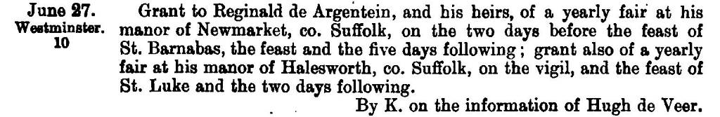
And then also on 17th February 1227 King Henry III granted Richard de Argentan a fair on vfm St Simon and St Jude:-
Calendar of Charter Rolls - Volume I - p.11 - King Henry III 1227
Feb 17.
Westminster.
Grant to Richard de Argentoein and his heirs that the sheriff of Suffolk shall come once a year to his manor of Newmarket to hold a view of frank pledge in his court there of the men of that manor, the said Richard and his heirs to have all the amercements arising therefrom ; grant also to the same of a weekly market on Tuesday at his manor of Haleswurth, and of a yearly fair at his manor of Newmarket on the vigil, the feast, and the morrow of SS. Simon and Jude.
p.11_-_King_Henry_III_1227.jpg)
-
That this new market was located on the Icknield Way is shown in a
deed printed by the Archaeological Institute (Norwich Volume, 22)
relating to the transfer of 'totum solarium meum lapideum quod se
extendit super Ykenildeweie' by 'Robertus filius Radulfi Brother de
Novo Mercato' - this translate as 'my whole outer solarium (an upper
storey jettied room with a sunny view) that extends over the
Icknield Way' by 'Robert son of Brother Ralph of New Market'.
The date of the deed is in the reign of King Henry III (i.e. before 16th November 1272).
-
One immediate observation must be made here - initially this
location was simply the site of the new market of Exning: it was not
the wholesale relocation of the village due to a devastating plague, as was
proposed in Victorian times by the Rev Thomas Frognall Dibdin, one-time vicar of
Exning.
Over time the stalls of the weekly market, and also the yearly and then latterly bi-yearly fair, slowly evolved into more substantial dwellings and the market eventually grew and evolved into the town of Newmarket that we know today.
-
de Argentœin of Wymondley
-
*Evidence for
the date 29th September 1204 comes from two sources:-
1) From the Argentein evidences in the British Library, Harleian MS 6072, fo 16 - 'Robtus de Insula dedit Rico de Argent' novam mercatam cum Cassandra filia sua in lib maritag'. This translates as 'Robert de Insula gave to Richard de Argent' Newmarket with Cassandra his daughter in free marriage'
2) Then the date of this marriage can be inferred from two entries in the Pipe Rolls of King John:-
Pipe Roll 1203 (Michaelmas):
Norfolk and Suffolk 'Et Roberto de Insula xl s. in eadem uilla [Exninge]' - 'And to Robert de Insula 40s in the same town [Exning]'.
Pipe Roll 1204 (Michaelmas):
Norfolk and Suffolk 'Et Ricardo de Argentoem xl s. in eadem uilla [Exninge]' - 'And to Richard de Argentoem 40s in the same town [Exning]'.
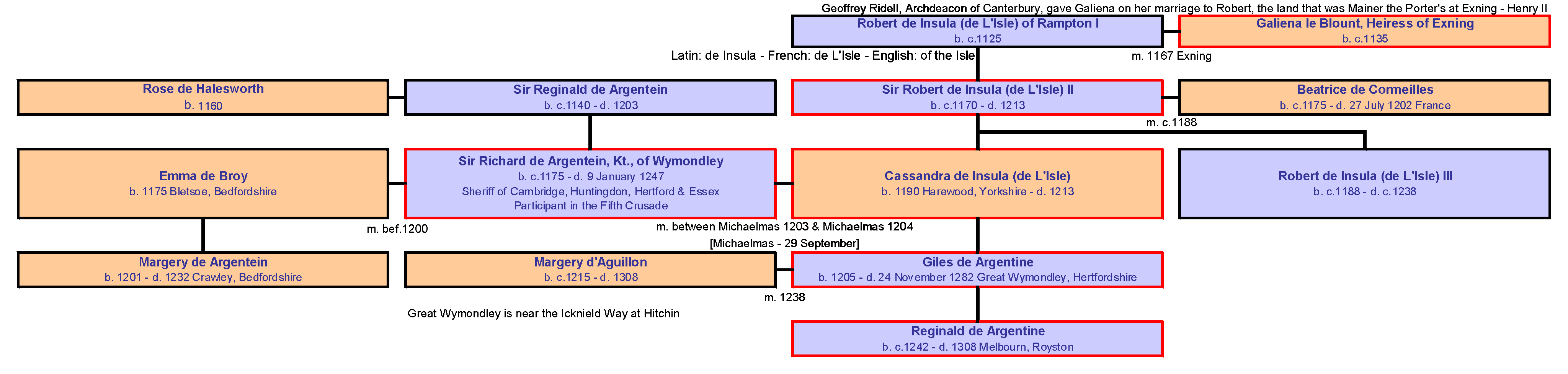
The de Argentein Family Tree
[click on the picture for a larger view]
[Note that as spelt in original records the correct form of the family name is de Argentœin, but for the sake of convenience this is most often written as de Argentein.]
-
Hence to expand on this and to give him his full title, Sir Richard de Argentein, Knight
of Wymondley had become Lord of the Manor of Exning and Newmarket by
his marriage to Cassandra sometime between these two dates.
Cassandra's paternal grandmother was Galiena le Blount, Heiress of Exning; hence the dowry of Exning from her father Sir Robert de Insula (de L'Isle). So from the details of this dowry it can therefore be surmised that Newmarket had existed before the date of Richard and Cassandra's marriage - i.e. before 29th September 1204 at the latest.
[Note that de Insula or de L'Isle is a Norman family name with origins from a variety of possible locations in France, it's not a name with reference to the Isle of Ely or any other English locality, as has been mistakenly surmised in many other historical references. Following the Norman conquest Sir Robert de Insula's family had originally settled in Yorkshire; so it's no surprise that Cassandra was born in Harewood, Yorkshire, even though the family manor at that time was mostly in Rampton, Cambridgeshire.]
-
de Novo Mercato

- One of the pitfalls in investigating the origins of Newmarket is unfortunately its name - it's not particularly unique - and in
Medieval times, as is still the case now there was more than one Newmarket.
- What must be also understood about these medieval times, in the
period shortly after the Norman conquest, is that more than one
language was in use in this country. As well as the native Brittonic
and Anglo-Saxon languages and dialects, more often than not the
spoken language by the nobility was French, or more specifically
Norman. But then for legal written documents the most common
language was Latin.
- Novum Mercatum or Novo Mercato is the Latin for new market.
Many of those who had the surname de Novo Mercato (of the new
market), who have previously been associated with our Newmarket, are now understood to be members of the Norman Neufmarche family (neufmarche being Norman / French for new market).
This family originated from Neuf-Marché in Nomandy, France. Coming over here as part of the Norman Conquest, they became lords of Wales and eventually settled in Yorkshire.
- One particular family member; Adam de Novo Mercato [note that there was more than one Adam in this family], born in 1215, was a steward to King Henry III. He lost his lands in 1264 during the
Second Barons' War and subsequently regained them in 1267.
Other members of that family even had lands at Kedington near Haverhill and this is where some confusion has previously crept in; by associating this to be in some way connected with our Newmarket.
Extensive research has shown that this particular land ownership was due to Geoffrey de Barnardiston of Suffolk marrying the daughter and heiress of Roger de Novo Mercato of the Yorkshire Neufmarche family.
Even John de Novo Mercato (1196-1243), who others have tried to assign as being from our Newmarket, was actually simply the father of the Adam de Novo Mercato detailed above - i.e. another member of the Neufmarche family.
In fact there are numerous mentions of de Novo Mercato in the Charter Rolls for King John (1199-1216), but all of these refer to members of the de Novo Mercato family and none about our new market.
The family name has continued all the way up to the present day as Newmarche.
- So it's important in any research about the town to
disregard these red herrings and remember that to wholly understand the evolution of our Newmarket you have to take account of its close associations with both the Icknield Way and also
with Exning, particularly the affairs of the de Argentein family.
-
The Second Barons' War
-
The Second Barons' War did have a direct influence on Newmarket. It
was a tumultuous time for the monarchy in this country and in May 1258 King Henry III made Giles de Argentein
(you can find him in the family tree above) one of the 12 members of the committee nominated by the barons
to help with their negotiations with the King.
At this same time Sir William de Valence (b. c.1220s- d. 18 May 1296), half-brother to the King was being granted many honours and various lands (much to the annoyance of the incumbent barons). This included the Suffolk manors of Kentwell and Exning amongst many others.
https://en.wikipedia.org/wiki/William_de_Valence,_1st_Earl_of_Pembroke
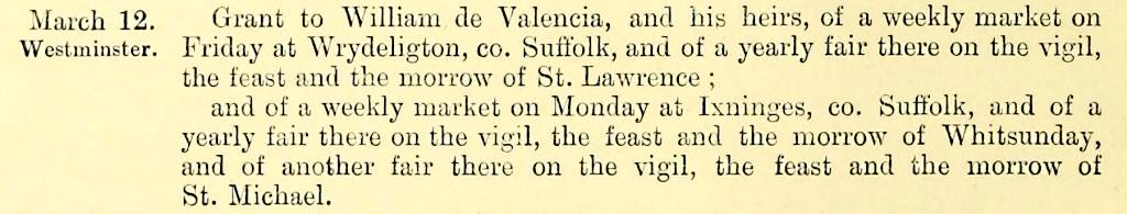
So clearly Giles was being kept far too occupied by the King's affairs to have time to manage his lands here at Newmarket and it's no surprise that in 1258 William de Valence was granted both a market and a fair here at Exning.
Calendar of Charter Rolls - Volume II - p.8 - King Henry III 1258
March 12.
Westminster.
Grant to William de Valencia, and his heirs, .... and of a weekly market on Monday at Ixninges, co. Suffolk, and of a yearly fair there on the vigil, the feast and the morrow of Whitsunday, and of another fair there on the vigil, the feast and the morrow of St. Michael.
-
After much protracted efforts, the negotiations between the King and the barons
failed and thus began the
Second Barons' War in 1264.
https://en.wikipedia.org/wiki/Second_Barons%27_War
Giles eventually sided with the rebels and on 4th August 1265, following their defeat at the Battle of Evesham he had his estates confiscated by the King - these included Weston, Wymondley, Lilley and Willian in Hertfordshire, Flitcham and Wilton (shown below as Wiltun - in the hundred of Grimshoe near Thetford) in Norfolk, Halesworth, Newmarket and Burton in Suffolk, Bumpstead in Essex and Pidley in Huntingdonshire.
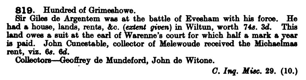
Calendar of Inquisitions Miscellaneous Volume 1 - 1265 p.249
Calendar of Inquisitions Miscellaneous Volume 1 - 1265 p.270
[Nofmarche is of course another way of spelling Newmarket at this time, as explained with the origins of the Neufmarche family above.]
-
As shown below William de Valence was eventually wholly granted half
of the lands at Exning.
Calendar of Charter Rolls - Volume II - p.84 - King Henry III 1267
-
The recovery of Newmarket
- Like many of his rebel companions, Giles eventually received the King's pardon in February 1266 and
he subsequently succeeded in recovering his principal estates at Melbourn, Wymondley,
Newmarket, Burton and also Halesworth.

Calendar of Inquisitions Post Mortem, Edward I, Volume 2 - 1282 p.275 & 276
- Although it's only a short paragraph this court record actually
gives us an absolute wealth of detail about the origins of Newmarket.
Giles de Argentein was clearly back in charge as Lord of the Manor, and although it was in Exning (Ixninge) parish, the manor was called Newmarket.
The arable land within the parish of Exning is clearly quite tiny at only 76 acres. And this was bringing in rental earnings of only 69s/year, which even in 1282 was already being outstripped by the earnings from the market at 100s/year. The new market was clearly taking on a far more important role in this area than the original parish of Exning ever did.
The windmill here existed even at that time. It lasted in use up to the early 20th Century, giving its name to Mill Hill in Newmarket.
The other very clear detail in this record is that this land was very obviously originally owned by Robert de Insula - matching entirely the dowry record detailed above.
-
As intimated in the above Calendar of Inquisitions Post Mortem Giles had died shortly before 24th November 1282, passing the Manor of Newmarket onto his son Reginald de Argentein.
Calendar of Charter Rolls - Volume II - p.429 - King Edward I 1292

-
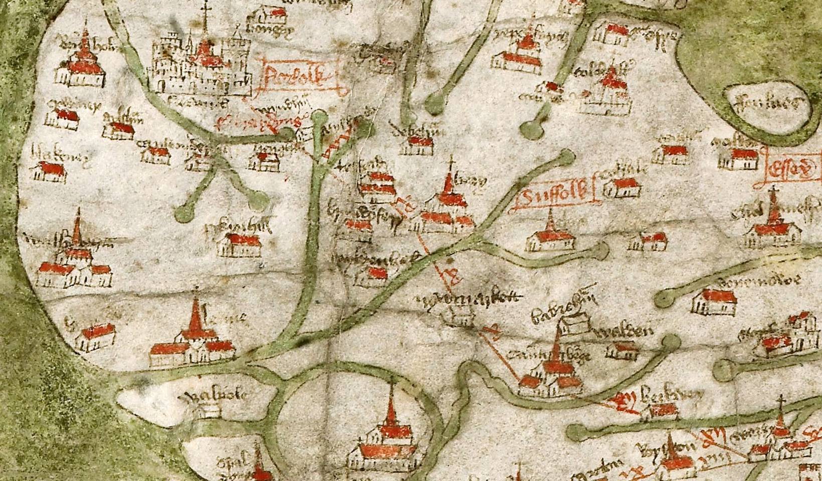
Newmarket in 1360
- The following is an extract from the oldest surviving route map of
Great Britain - generally known as the Gough Map. Drawn sometime
around 1360, the map needs a little explanation; as it doesn't
conform to modern cartographic conventions (i.e. North at the top).
On this map North is on left; so the coastline you can see there is
the North Norfolk coast. The East coast is out of view at the top of
the map.
Suffolk is clearly shown (in red writing) and to the left of this is bury (St Edmunds). Just below this is Newmarket (nywmarkett) and then to the right and below that is Babraham and Cambridge (cauntebrege).
Exning - 'Ixninge' doesn't even get a mention; so has clearly become of much less importance compared to the new town by this time.
https://en.wikipedia.org/wiki/Gough_Map
-
Chapels of St Mary
-
To cater for the ecclesiastical needs of the people of Newmarket, as shown in the Calendar of Inquisitions Post Mortem for 1282, the town had the advowson of a chapel.
This was the chapel of the Blessed Virgin Mary, which originated as a chapel of ease to St
Martin's church at Exning.
Eventually of course this area became an independent parish and the church became St Mary's Newmarket, which according the church's own records happened sometime in the 16th Century.
-
Coming back to the originations of the town on the Icknield Way
though,
note that a large part of this was in the Cambridgeshire parish of Ditton Valence (Woodditton), and not to be outdone by the Suffolk
parish of Exning, in 1336 the Lord of that Manor built another chapel of St Mary at Newmarket in their parish.
These dual chapels of St Mary existed up until sometime before 1509, when this latter chapel became the church of All Saints.
-
The evolution of these parishes therefore very clearly explain why the larger part of the town was in Suffolk and the later and smaller part was in Cambridgeshire.
Although of course this all changed in 1889 when the part of the parish of Woodditton that was in the Urban District of Newmarket became part of West Suffolk, and then on 1st October 1895 this area then became part of the parish of Newmarket All Saints.
This boundary transition is not entirely complete though; as even now there parts of Newmarket that are still in Cambridgeshire and the parish of Woodditton.
- Note of course that the part of Woodditton known as Ditton Valence,
originated the ending of its name from the one-time ownership by the same de Valence family
as detailed above,
most probably Aymer de Valence, 2nd Earl of Pembroke (b. c.1275 - d. 23 June 1324), son of the William de Valence,
who temporarily was Lord of the Manor of Exning.
https://en.wikipedia.org/wiki/Aymer_de_Valence,_2nd_Earl_of_Pembroke
Aymer was also granted lands in the Manor of Exning.
County of Suffolk: its history, by Walter Arthur Copinger 1847-1910
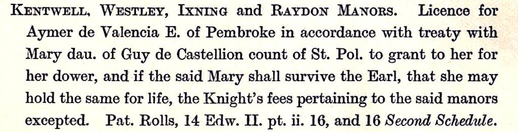
Pat. Rolls, 14 Edw.II.pt.ii. 16, and 16 Second shedule.
1321
KENTWELL, WESTLEY, IXNING and RAYDON MANORS. Licence for Aymer de Valencia E. of Pembroke in accordance with treaty with Mary dau. of Guy de Castellion count of St. Pol. to grant to her for her dower, and if the said Mary shall survive the Earl, that she may hold the same for life, the Knight's fees pertaining to the said manors excepted. Pat. Rolls, 14 Edw. II. pt. ii. 16, and 16 Second Schedule.
-
By Street, by Way, by Parish, by Manor, by County - Newmarket in Suffolk (?)
-
Even now there are certain historical evidences showing that the
divisions of all these various boundaries and the route of the
Icknield Way need further investigation to make better sense of the
historical evolution of Newmarket.
-
Parishes are ecclesiastical districts, originating in Anglo-Saxon
times, being defined by their associations with a particular church
and a designated priest. Manors on the other hand are defined by
land ownership and usage. Then we have the counties of Medieval
England, which existed primarily as a means of enforcing central
government power, enabling monarchs to exercise control over local
areas through their chosen representatives, originally Sheriffs.
These were in most cases based on earlier Anglo-Saxon kingdoms and
shires.
What's important to understand amongst all this is that the boundaries between these various types of district do not necessarily have to be coincident with each other.
- Going back to one of the old records for this area we have the
Domesday Survey; enacted by William the Conqueror 19 years after the
Norman Conquest, performed in order to make an account of the extent
and ownership of land within his conquered domain.
In this document Exning is known as Esselinge and Woodditton as Ditone.
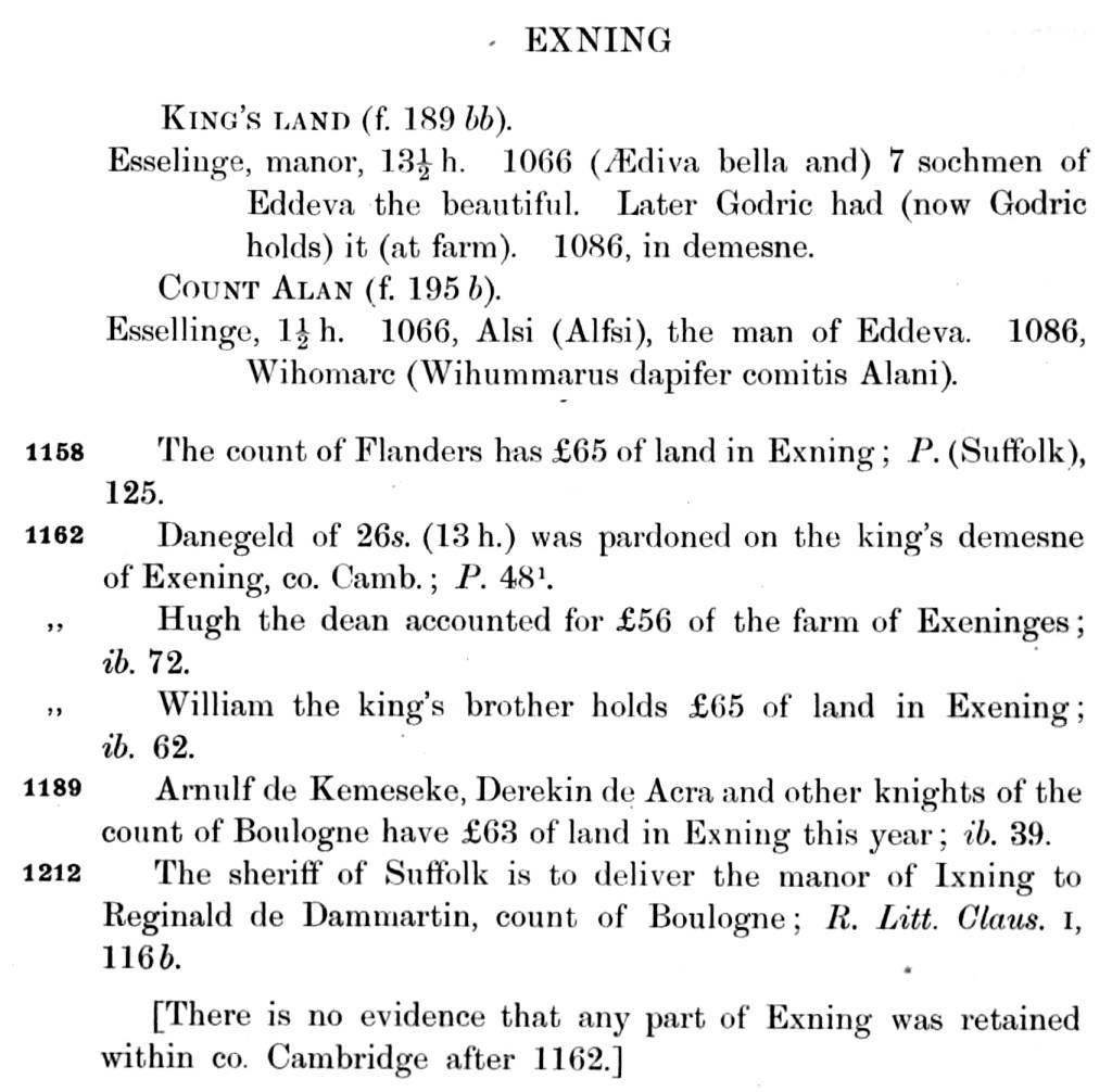
The Domesday Book - December 1085
Exning
Esselinge
Hundred: Staploe
County: Cambridgeshire / Suffolk
Total population: 88 households (very large).
Total tax assessed: 15 geld units (very large).
Exning appears in 2 entries in Domesday Book.
ENTRY 1
Taxable units: Taxable value 13.5 geld units. Payments of 0.23 miscellaneous.
Value: Value to lord in 1066 £56. Value to lord in 1086 £53. Value to lord c. 1070 £12.
Households: 35 villagers. 34 smallholders. 7 slaves.
Ploughland: 34 ploughlands (land for). 7 lord's plough teams. 3 lord's plough teams possible.
24 men's plough teams.
Other resources: Meadow 4 ploughs. 3 mills, value 1.0.
Lord in 1066: Edeva the fair.
Lord in 1086: King William.
Tenant-in-chief in 1086: King William.
Phillimore reference: 1,12
ENTRY 2
Taxable units: Taxable value 1.5 geld units.
Value: Value to lord in 1066 £3. Value to lord in 1086 £2.5. Value to lord c. 1070 £2.5.
Households: 4 villagers. 8 slaves.
Ploughland: 3 ploughlands (land for). 2 lord's plough teams. 1 men's plough teams.
Other resources: Meadow 2 ploughs. 1 mill, value 0.26. 1 fishery.
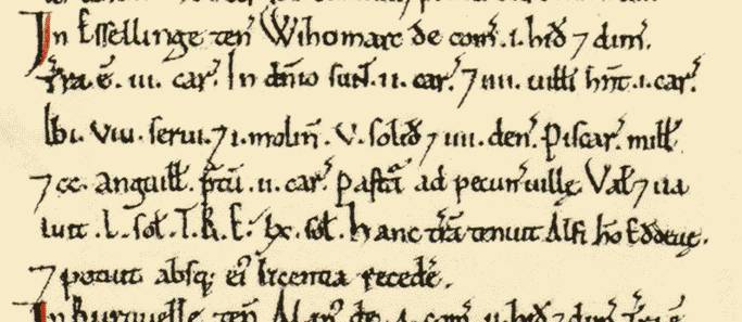
Lord in 1066: Alsi (illing).
Overlord in 1066: Edeva (the fair).
Lord in 1086: Wiuhomarch {the steward}.
Tenant-in-chief in 1086: Count Alan (of Brittany).
Phillimore reference: 14,68
Woodditton
Ditone
Hundred: Cheveley
County: Cambridgeshire
Total population: 35 households (very large).
Total tax assessed: 15 exemption units (very large).
Woodditton appears in 2 entries in Domesday Book.
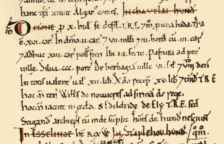
ENTRY 1
Taxable units: Taxable value 10 exemption units. Taxed on 1.0.
Value: Value to lord in 1066 £15. Value to lord in 1086 £12. Value to lord c. 1070 £15.
Households: 7 villagers. 3 smallholders. 3 slaves.
Ploughland: 16 ploughlands (land for). 2 lord's plough teams. 3 men's plough teams.
Other resources: Woodland 300 pigs.
Lord in 1066: Ely (St Etheldreda), abbey of.
Lord in 1086: William of Noyers.
Tenant-in-chief in 1086: King William.
Phillimore reference: 1,11
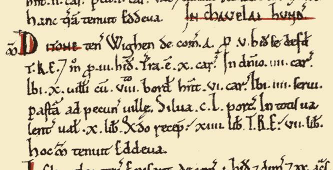
ENTRY 2
Taxable units: Taxable value 5 exemption units. Taxed on 3.0.
Value: Value to lord in 1066 £7. Value to lord in 1086 £10. Value to lord c. 1070 £14.
Households: 10 villagers. 8 smallholders. 4 slaves.
Ploughland: 10 ploughlands (land for). 4 lord's plough teams. 6 men's plough teams.
Other resources: Woodland 150 pigs.
Lord in 1066: Edeva {the fair}.
Lord in 1086: Wighen {Delamere}.
Tenant-in-chief in 1086: Count Alan (of Brittany).
Phillimore reference: 14,61
Domesday Book images made available by Professor J.J.N. Palmer and George Slater on Open Domesday.
 http://opendomesday.org/
-
One immediate point of note here is that at the time of the Norman Conquest in 1066 Edeva (Eadgifu) the Fair was Lord and Overlord of the two parts of Exning and also Lord of one of the parts of Woodditton, so the boundary divisions between these various manors was already less than obvious even at that time.
-
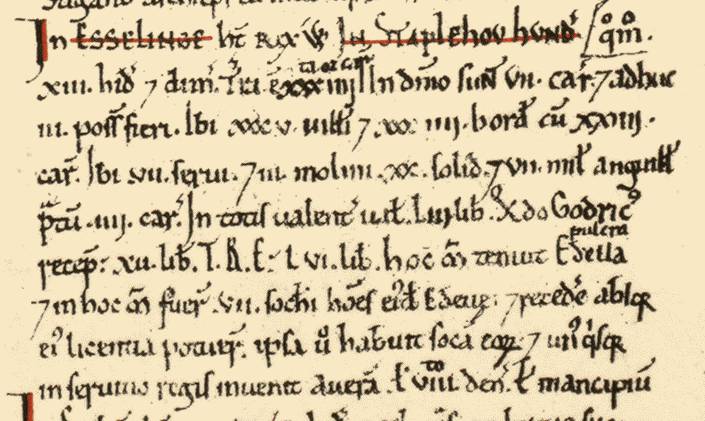
There’s also one key fact that’s shown, but not highlighted in the above online Domesday Book record - Exning was originally in the Staploe Hundred, and as such in 1066 it was in Cambridgeshire.
-
Following the Norman Conquest Edeva was stripped of her lands and Exning was given to Ralph de Gaël, who King William made Earl of the East Angles (Norfolk and Suffolk).
Then the story goes that in 1075 Ralph married Emma (de Breteuil), the daughter of William FitzOsbern, 1st Earl of Hereford. Although not universally accepted, it’s thought that the King refused to sanction the marriage between these two powerful families. There are other theories, but whatever did happen this subsequently caused a revolt against the King, now called the Revolt of the Earls.
https://en.wikipedia.org/wiki/Revolt_of_the_Earls
This revolt failed miserably though, eventually causing Ralph and Emma to flee to Brittany. So that by the Domesday record in 1086 the larger part of Exning was under the King’s direct command, with his Steward; Godric (who’d previously administered Ralph’s estates in Essex, Norfolk and Suffolk), now managing this part of Exning. [if you look at the above image for Esselinge, Entry 1 from the Domesday Book, on the centre-right side you can see Godric’s name].
Godric served as Sheriff of Suffolk c. 1087-1100, so it may have been he who transferred Exning to his new bailiwick [his jurisdictional district], and hence into the jurisdiction of the county of Suffolk.
-
The other part of Exning (Entry 2 in the Domesday Book) passed into the hands of Count Alan of Brittany, who’d also succeeded to other lands previously held by Earl Ralph. This area continued to be within Cambridgeshire (presumably this part became Landwade).
https://en.wikipedia.org/wiki/Alan_Rufus
-
As is still shown on the 1845 map above, from 1158 the vill of Exning, which formed an irregular rectangle, separate but within the shape of the Staploe Hundred, was normally included in the farm due from the sheriff of Suffolk.
Exning is listed in the Great Pipe Roll of King Henry II in 1162 .... but in that document it's shown as being in both Cambridgeshire and in Suffolk.
William Farrer's 1920 book 'Feudal Cambridgeshire' (shown above) lists translations of these Pipe Roll entries, and the first reference for Exning from page 48 of the Pipe Roll is that it's part of the King's demesne [domain / manor] in Cambridgeshire.
The second Pipe Roll entry from page 72 is just an isolated listing for Exning, with no details of any county.
The last entry for Exning though, from page 62 of the Pipe Roll, is in the section for Suffolk .... and this contains an extremely interesting detail - that in 1162 the King's brother William held £65 of land in Exning. Many thanks to Dr Rachel Wood from the Newmarket Library Group for her detailed knowledge of Latin and investigative skills, who on confirming this translation has discovered that this refers to William FitzEmpress (1136-1164), also known as Williami d'Anjou.
https://en.wikipedia.org/wiki/William_FitzEmpress
Details from the Oxford DNB (Ref.46709) have him as being born on 22nd July 1136, the youngest of the three sons of Geoffrey Plantagenet, Count of Anjou and Matilda (Maude), Empress of Germany - so his oldest brother was indeed King Henry II of England. Shortly after Henry came to the throne in 1154 he gave William many land holdings in England, and by 1162 this amounted to 500 hides (60,000 acres) in fifteen counties, making him one of the wealthiest men in the kingdom.
And then it gets really interesting - William was born in Argentan in Normandy .... this is the exact same location that the de Argentein family originated from (Argentan / Argentein - it's the same word).
No familial link has yet been found between William FitzEmpress and Richard de Argentein, but the coincidence of them coming from exactly the same town in France must mean that there's some common association - and it's only 42 years between their ownerships of Exning (1162 / 1204).
-
To further confirm this locality of Exning being in Suffolk let's go back to an earlier record. The detail comes from the 'Chronicon Monasterii de Bello: Nunc primum typis mandatum', the 'Chronicle of Battle Abbey' [Battle in Sussex - near Hastings].
William Rufus, King William II of England (third son of William the Conqueror), consecrated the abbey on the 3rd of the Ides of February in the 8th year of his reign - 11th February 1095 (N.S.). At that ceremony he 'conferred upon the Abbey, out of his domain, certain churches in Suffolk, Norfolk, and Essex', one of these being Exelinges in Suffolk - i.e. Exning church.
Hence once again here's another early record defining Exning as being in Suffolk in 1095.
-
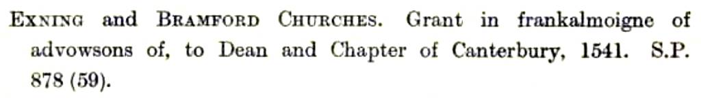
Exning church and rectory continued to belong to Battle Abbey up until the Dissolution of the Monasteries by King Henry VIII (1536- 1540) and was only acquired by the dean and chapter of Canterbury in 1541.
(extract from 'Battle Abbey Charters, Grants, Deeds, &c.')
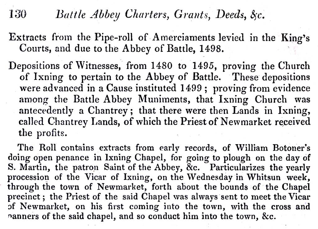
(extract from 'Battle Abbey Charters, Grants, Deeds, &c.')
[S.P. - Calendar of State Papers]
-
The latter of the extracts from the Battle Abbey Charters shown above clearly highlights the close ties that still existed between the town of Newmarket, it's chapel and the church at Exning.
-
Medieval markets
-
Quarrels over markets were common in Medieval times, because of the money they could generate for those owning the manorial rights.
-
The Cambridge borough charter of 1120-1131 restricted the presence of a market there to
one solely being in Cambridge itself, with no other markets allowed in the county.
But by around 1200 when Exning achieved its market charter the village was in Suffolk, so it escaped that particular restriction.
-
Exning did come within the liberty of Bury St Edmunds though (West Suffolk), where in 1201 King John had granted the abbot and monks of the abbey a charter restricting the founding of any new markets within the borough, that they must not be harmful to
the trade of the market there.
Lakenheath fell foul of this limitation and in 1202 King John ordered closure of its market (which had been run under a previous charter held by the monks of Ely). This wasn't without some resistance though and in order to close the market abbot Samson had to send 600 armed men to destroy the stalls and confiscate their livestock (he did get into trouble for doing this though).
-
For some reason Exning escaped this wrath, it's not known quite why (it's about the same distance away from Bury St Edmunds as Lakenheath) - maybe Exning's close royal associations had some bearing on the matter(?).
Because of these severe restrictions on any new markets though it becomes very obvious that unlike as has been previously proposed by others, that there had been more than one chartered market in this vicinity at various times (separate markets in Exning and in Newmarket), only one market would ever have been allowed here - i.e. any charters issued for Exning must have been for the new market .... once again highlighting that Newmarket was originally part of Exning and not an independent location.
-
A Foot in both camps - Suffolk & Cambridgeshire
-
One aspect of the physical locations of these various boundaries is that there are no detailed Medieval maps extant for this area - the earliest local map of Newmarket is Chapman's map of 1768, the Staploe Hundred map above is from 1845 - so knowing which part of the land is which in earlier times is only deducible by vague descriptions in written records such as the Pipe Rolls; not a particularly conclusive method when it comes to drawing lines on the ground.
-
Coming back to the Icknield Way - on Peter May's 1472 map of Newmarket (constructed from detailed court records at that time), there are already 2 major highways going through the town - the High Street and the Ikenelseway, converging at what's now the Rutland Hill.
Now it's already been stated above that the Icknield Way is known to have been more than one track through the area, but the question has to be asked - if the 'Way' was the reason why the market came here in the first place, why is the market located at the side of the High Street and not next to the Icknield Way?
Records have it that the High Street has been the churches' parish boundary between Esselinge (Exning) and Ditone (Woodditton) since Anglo-Saxon times, so by inference this also came to be the county boundary between Suffolk and Cambridgeshire .... but careful consideration of all the above historical details does seem to raise an unanswered question - in what county was that small plot of land between the High Street and the Ikenelseway? Clearly in later times this area was in Cambridgeshire and also part of All Saints parish, but from details in the older records it's not at all obvious where the county boundary was.
Also as detailed above, on 6th November 1267 William de Valence was granted half of the lands at Exning. Then sometime around 1300 William's son Aymer became Lord of the manor of Ditone - Ditton Valence (which we do know that later this manor extended all the way up to the High Street). There's also the record in the Patent Rolls that in 1321 Aymer was granted land in Exning.
- One useful set of records showing land distribution in the
counties of Great Britain is the Feet of Fines. The use of Fines was
a means of creating a legal record of land ownership.
The Foot of Fine (plural, Feet of Fines - Pedes Finium) is the archived copy (the foot of the document) of a three part legal agreement, which in essence detailed the conveyance of land between two parties.
Each of the participants in the transaction was given one half of the upper section of the Fines, showing duplicate information of the land conveyance agreement.
Records of Feet of Fines exist between 1195 until 1833, when they were abolished.
-
The following images are extracts from late Victorian transcripts of
the 'Feets', showing just the calendar details of the records (the
original documents are much more detailed and in Latin). These
transcripts give the year of the record, its reference number from
the archived originals, the names of the Purchaser and Seller plus
the location of the land.

(extract from the Feet of Fines for Suffolk - 1307)
This record shows Robert de Marham of Newmarket buying from Richard de Icklingham also of Newmarket, land in Exning.
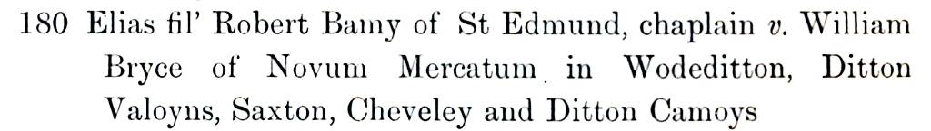
(extract from the Pedes Finium for Cambridgeshire - c.1320)
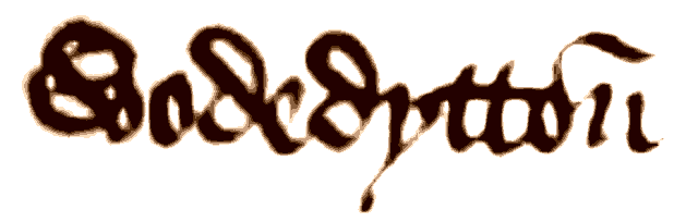
So for this record we have Elias, son of Robert Bamy, the chaplain of Bury St Edmunds, buying from William Bryce of Newmarket, lands in Woodditton, Ditton Valence, Saxon Street, Cheveley and Ditton Camois.
These extracts clearly show the close tie-ins that existed between Newmarket and its adjacent village manors, plus most probably what was the beginnings of the progressive expansion of the town out into these districts .... Newmarket was slowly getting bigger.
- This duality between the manors in this area is still present in a
land deed from 1548 - when the Lord of the Manor of Ditton Valence
(Valens) had appurtenances (subsidiary land) in Exning.
Deeds: B.1501 - B.1600
A Descriptive Catalogue of Ancient Deeds: Volume 1, ed. H C Maxwell Lyte (London, 1890)
pp. 359-368
Camb. B. 1548. Release by John de Bletnesho (Bletsoe), chaplain, to Henry Englis, of his right in the manor of Ditton Valens and its appurtenances in Ixningge (Exning) and Newmarket, which manor he had of the feoffment of Euphemia. relict of John Walkefare. Friday after St. Margaret the Virgin, 37 Edward III. Seal.
[The above written image is from the Feet of Fines for 20th January 1428 and by that time the two manors of Ditone were being listed as Wodedytton.]
-
And then coming back to Newmarket itself, the part wholly in Suffolk, a large section of the town was still part of the Exning Estate all the way up until June 1881, when the land was put up for auction. Further details about this sale can be found on the page for No.156-160 High Street.
As detailed on that page:-
The Jockey Club bought Lot 1 for £165,000 (The main portion of the Estate with The Mansion and 2400 acres of 'very fine land') and Lot 3 for £25,000 (An important tract of Building and Accommodation Land adjoining the Heath at the west end of Newmarket, approx. 138 acres). Lots 1 and 3 adjoin the racecourse. Their reason for this purchase was 'to prevent the building of houses overlooking the course'.
-
The importance of Newmarket
Reminding ourselves about the regal importance of this area - going back to those Domesday records, the Tenant-in-chief in 1086 for the largest part of Exning was William Rex, King William - William the Conqueror himself. Even Sir Richard de Argentein, who became Lord of the Manor of Exning in 1204, was cupbearer (a very important position) for King Henry III (a royal honour that had started with his Great Grandfather Reginald de Argentein and continued in the family for more than 600 years) - so there have been strong royal associations for this area going all the way back to 1086 ... which is a long time before King James I rode through in 1605 and subsequently had his palace here ............. on the plot of land between the High Street and the Ikenelseway.
As stated above it's thought that the new market was created in around 1200 - interestingly one other occurrence happened just before then that could very well have had a major influence on circumstances - the river Kennett was forded in around 1161 - this would have had an immediate beneficial effect on the ease of access and the amount of traffic going through the area: as suddenly a major blockage on the Icknield Way had been removed.
Subsequently in the early c.15th a Pack-Horse bridge was built over the river [The Will of Richard Haddenham who died in 1542 details a bequest: 'To the reparation of the causey from Kentford Bridge to my door 6s 8d']. This bridge was contemporary with the still extant bridge at Moulton. The bridge was considered a very fine example of its kind, with at least four arches of brickwork and flint rubble.
This improved track subsequently allowed the 'Way' to eventually become a busy turnpike, running through the centre of town and right past the market - allowing Newmarket to flourish.
One aspect that does seem does seem to come though all of this is that the location of this new market was clearly highly important, for a variety of reasons and land ownership at this location has always been highly contested and has been constantly been changing hands between the various Lords of the Manor and a variety of tenants for some length of time.
With those campaigning even today to return Newmarket back to Cambridgeshire the story of this complexity of boundaries still isn't over.

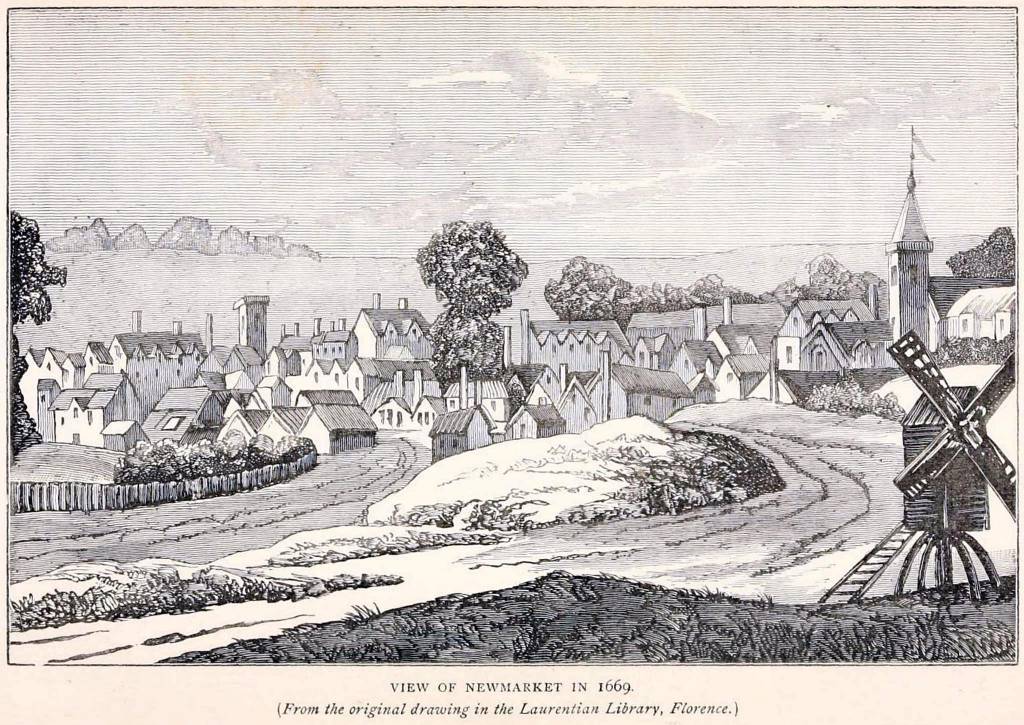
Newmarket High Street c.1913
 Extract from Feudal Cambridgeshire - by William Farrer - Published 1920 |
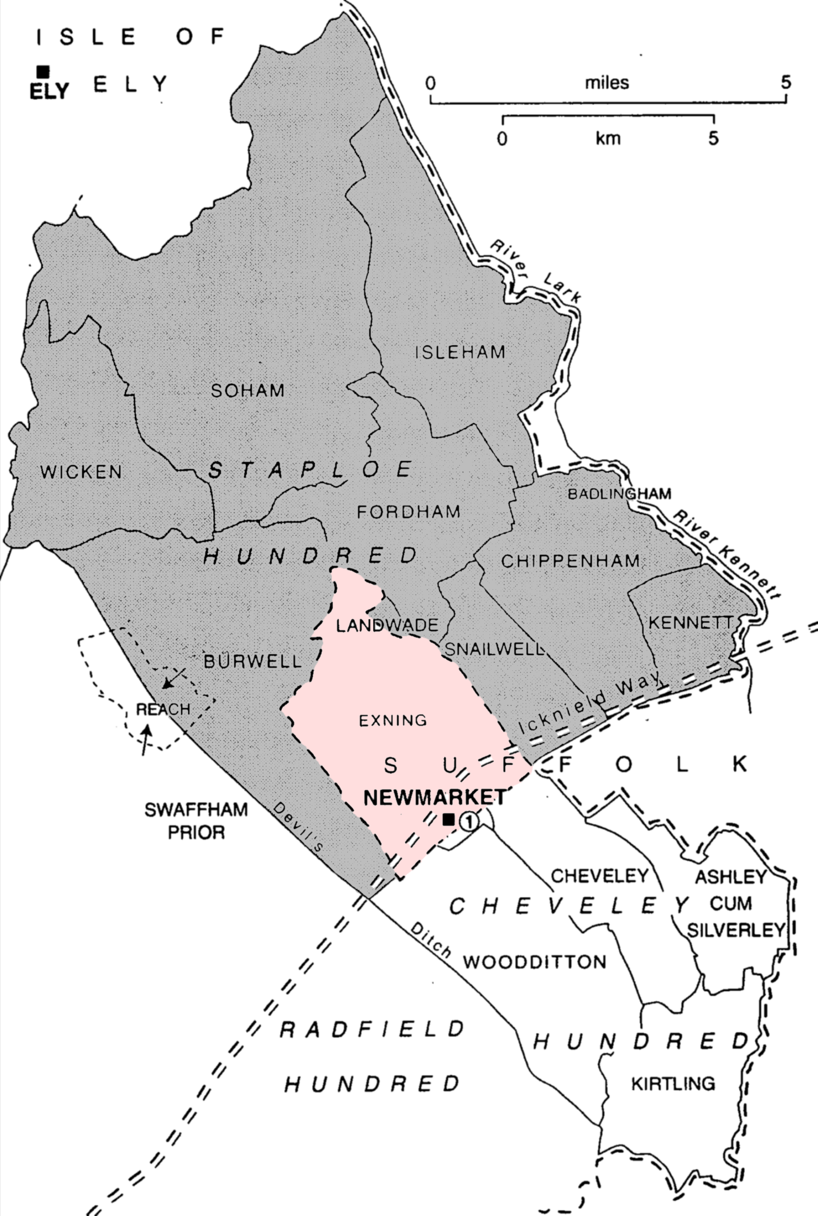 Staploe Hundred & Exning 1845 [The small area labelled (1) denotes All Saints parish, which was a separate entity at that time - it hadn't been fully devolved from Woodditton parish and it had yet to be subsumed by Newmarket, as detailed in the section above entitled 'Chapels of St Mary'. Note that this map is highly diagrammatic and the route of the Icknield Way shown by the cartographer has used a lot of artistic license .... it in no way identifies any of the actual possible routes of the track through Newmarket.] |
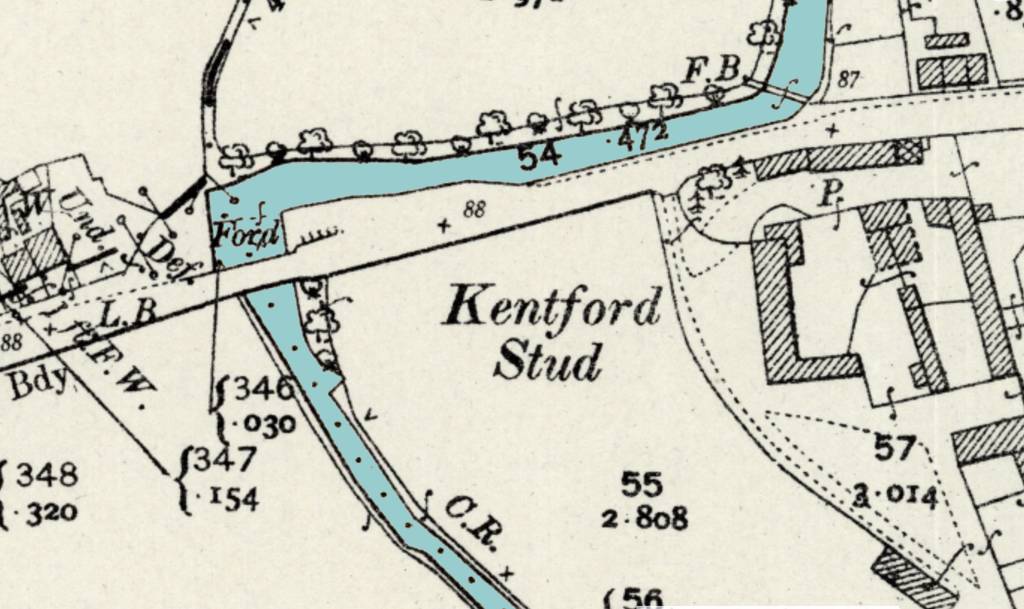 Kennett Ford Map 1901 - the River Kennett (shown in blue) forms the boundary between Kennett on the left and Kentford on the right [Reproduced with the permission of the National Library of Scotland] |
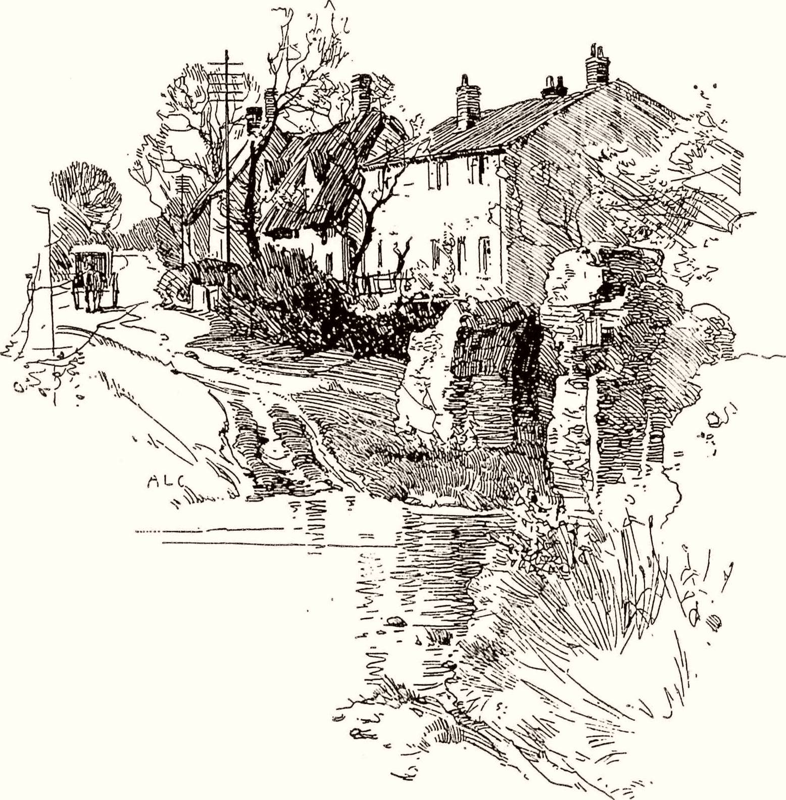 Looking towards Newmarket - the Icknield Way through Kennett and Kentford - the ford is clearly visible in the centre, with a few remaining pillars of the Pack-Horse bridge on the right - these were finally washed away when the river flooded in the the mid 1970s |
- Return to top of page
| IMPORTANT
NOTE from the WEBMASTER Content on this web site is attributed as appropriate to its original source or supply - can I ask that any copying or subsequent citation should respect the original author(s) and reference them or this web site as the source of this material Thank you |
|
| © 2015 | |
Note:- all historical dates on this web site use the New Style (N.S.) calendar format (where the year starts on 1st January). Any dates in Old Style (O.S.) calendar format have been corrected for their year of occurrence as required. The change of the start of the year and the changeover from the O.S. calendar occurred in 1752 under the 'Calendar (New Style) Act 1750'. The changeover also involved a change of dates as well (which is another matter) - for more details click HERE. |
|